


New Zealand Topo Maps
Deskripsi New Zealand Topo Maps
Aplikasi navigasi luar ruang yang mudah digunakan dengan peta topografi terbaru dari Selandia Baru, Kepulauan Cook, dan Tokelau.
Aplikasi ini memberi Anda opsi pemetaan yang sama seperti yang Anda ketahui dari perangkat GPS Garmin atau Magellan.
Fitur utama untuk navigasi luar ruangan:
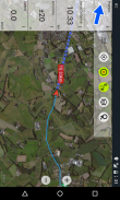
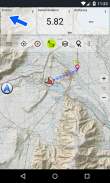
• Buat dan edit Waypoints
• GoTo-Waypoint-Navigasi
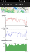
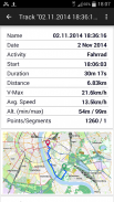
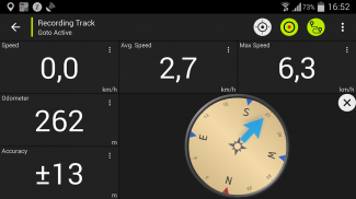
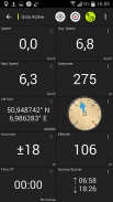
• Rekaman Track (dengan profil kecepatan, ketinggian, dan akurasi)
• Tripmaster dengan bidang untuk odometer, kecepatan rata-rata, bantalan, ketinggian, dll.
• GPX-Impor / Ekspor, KML-Ekspor
• Cari (nama tempat, tempat tujuan, jalan)
• Ladang data yang dapat dikustomisasi dalam Tampilan Peta dan Tripmaster (mis. Kecepatan, Jarak, Kompas, ...)
• Bagikan Waypoints, Tracks atau Routes (via eMail, Facebook, ..)
• Gunakan Koordinat dalam UTM, WGS84 atau MGRS
• dan masih banyak lagi ...
Lapisan peta dasar yang tersedia:
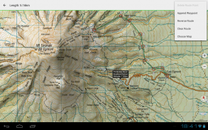
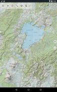
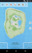
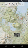
• Topomaps Selandia Baru (cakupan tanpa batas pada skala 1: 250.000 dan 1: 50.000)
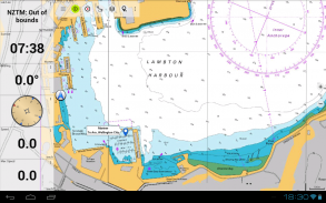
• NZMariner (RNC Nautical Charts)
• Citra Udara LINZ
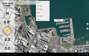
• Google Maps (Gambar satelit, Peta Jalan dan Medan)
• Buka Peta Jalan
• Peta Bing
• Peta ESRI
Lapisan overlay:
• Area Konservasi Publik
• Area Perburuan Terbuka
• Situs Kamp DOC
• Pembatasan DOC Freedom Camping
• Pondok DOC
• DOC TRacks
• Distrik Memancing Trout Taupo
• Hillshading
Gunakan aplikasi navigasi ini untuk kegiatan di luar ruangan seperti hiking, bersepeda, berkemah, memanjat, naik kuda, bermain ski, kano, atau wisata 4WD offroad.
Muat ulang data peta GRATIS untuk area tanpa layanan seluler. (Hanya versi Pro)
PEMBATASAN VERSI GRATIS:
• Iklan
• Maks. 3 Waypoints
• Maks. 3 Lagu
• Tidak Ada Rute
• Tidak ada impor titik arah dan trek
• Tidak Ada Unduhan Massal
• Tidak Ada DB Kota Lokal (Pencarian Offline)
Peta topografi dibuat oleh Land Information New Zealand (LINZ).
Topo50 adalah seri peta topografi resmi yang digunakan oleh layanan darurat Selandia Baru.
Bagaimana informasi topografi digunakan
Perencanaan pertahanan: Pasukan pertahanan Selandia Baru menggunakan informasi topografi untuk merencanakan latihan militer dan bertukar informasi dengan mitra internasional.
Lokasi dan perutean: Pencarian dan Penyelamatan, pertahanan, ambulans, dinas pemadam kebakaran, polisi dan lembaga pertahanan sipil menggunakan informasi topografi dalam berbagai situasi perencanaan dan operasional, dari bencana alam hingga kepolisian masyarakat. Penggunaan dapat melibatkan situasi ruang bergerak / lapangan dan ruang kontrol, dan kombinasi informasi topografi dengan data lainnya.
Pengelolaan lahan: Informasi topografi digunakan oleh pemerintah daerah untuk perencanaan dan operasi regional, dan oleh perusahaan listrik, gas, dan telekomunikasi.
Selain itu, peta LINZ digunakan untuk berbagai keperluan oleh bisnis dan departemen pemerintah seperti Departemen Konservasi, dan oleh pengguna rekreasi seperti penginjak-injak dan wisatawan.
Semua peta topografi memiliki label tambahan untuk keterbacaan yang lebih baik pada skala zoom yang lebih tinggi. Peta dirender dengan Atlogis® hillshading untuk meningkatkan topografi.
Cakupan Peta Topo:
Selandia Baru dan Kepulauan (Antipodes, Auckland, Bounty, Campbell, Chatham, Kermadec, Raoul, Snares, dan Stewart Islands) pada skala 1: 50.000 dan 1: 250.000
Kepulauan Cook (Aitutaki, Atiu, Mangaia, Manihiki, Mauke, Mitiaro, Palmerston, Penrhyn, Pukapuka, Rakahanga, Rarotonga, Suwarrow, Takute) pada skala 1: 25.000
Kepulauan Tokelau (Atafu, Nukunonu, Fakaofo) pada skala 1: 25.000
Silakan kirim komentar dan permintaan fitur ke nzmaps@atlogis.com
New Zealand Topo Maps - Versi 7.8.1
(17-05-2025)New Zealand Topo Maps - Informasi APK
Versi APK: 7.8.1Paket: com.atlogis.nzmaps.freeVersi Terakhir dari New Zealand Topo Maps
Versi lain


 4.35
4.35


Aplikasi pada kategori yang sama

Anda juga mungkin suka...


Aplikasi pada kategori yang sama


